Azekah - at the Valley of Elah
 Ancient Azekah, known today as Tel-Azekah is located in the heart of the Judean Lowland and once dominated a strategic road junction in the Holy Land. The city sat at an intersection of the roads which led from the lowland at west to the Judean Mountains at east, and a road from Beth-Shemesh, just north to Azekah, towards Lachish to the south. This north-south road is the historical location of the Kingdom of Judah’s western border at the First Temple period in the Holy Land. Its strategic location made Azekah a key element in a line of fortified cities along the border line.
Azekah was one of the first sites to be excavated in the holy land. Archaeological digs conducted by American archaeologist, Dr. Frederick J. Bliss between the years 1899-1900, revealed that Azekah was first inhabited as early as 1400 BC. Artifacts of Mycenean-Greek origin from this level indicate that the early inhabitants of the city had an active overseas trade with Greece.
Azekah in the Bible
 |
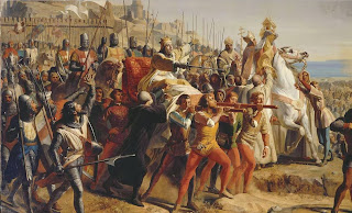
| An engraving depiction by Gustave Dore for the Biblical- account of the Hailstones on the Amorites at Azekah |
The book of Jeremiah 34:7, mentions Lachish and Azekah as the only fortified cities remaining in the kingdom of Judah, along with the capital Jerusalem, in the face of the Babylonian siege.
Azekah was resettled by Judeans in the Persian period following Cyrus the Great's policy of allowing exiles to return to their homelands, as indicated in the book of Nehemiah 11:30.
Azekah outside the Bible
 |
| Ostracon #4 from the Lachish letters - last two lines read: "…for we cannot see anymore the fire-signals of Azekah” |
Later History
 |
| A southwest view from the top of Tel-Azekah - towards the direction the Judean guards would have watched - beyond the horizon, Philistia |
In the first century AD, Jewish rebels dug caves on the hillside of Tel-Azekah and used them as a hideout place, during the Bar Kokhba revolt against the romans.
Further on into the Byzantine period, the name of Azekah was replaced with Kefar Zechariah. The city appears by its new name on the Madaba Map, from the 6th century AD, showing a large church at the site of Azekah bearing the inscription: "Sanctuary of St. Zacharias". There were some suggestions made that the Greek sound of the name "Zacharias" retains the original name of Azekah.
Present days
Today, Azekah is a part of the British Park in Israel, which extends over 10,000 acres in the Judean Plain.
Over a hundred years after it was first excavated, a team of archaeologists led by Tel Aviv and Heidelberg Universities returned in 2012 to Tel Azekah. The teams are working in an ongoing effort to reveal the history of the ancient city which was forced to be re-buried after its first dig, during the Ottoman rule in the Holy Land.
 |
| A panoramic image illustrating the strategic location of Tel-Azekah (to the left) as a dominating point over the Valley of Elah (on the right side of the picture) - the valley was used in ancient times as a main passage way to Jerusalem |
Available in our Etsy shop: